


The National Geographic expedition explored the Vilcún cave paintings that are in the south of Chile. The area, known as Santa Bárbara, also includes the Chaitén volcano, which is one kilometer from the coast. The team of twelve experts was led by Karen Holmberg, a professor at New York University, who, for many years, has been studying how volcanic activity redistributes human populations.
The project was called “The Vilcún Caves and the volcanic landscape of Chaitén, Chile: a transdisciplinary study of coastal conservation and archeology and the geological heritage of Patagonia”, and was made possible thanks to the National Geographic Explorer scholarships that financed the initiative.
For almost a month, scientists studied the area, cave paintings and engravings as well as animal remains, tools made of stone and bone, which indicated that human groups lived there more than seven-hundred years ago. The archeological remains found during the excavations are currently being analyzed in the lab.
To study this human adaptation in volcanic areas, identifying the site’s geological heritage and understanding the cultural and environmental contexts of the ancient populations, the project used digital tools to reconstruct the inside of the caves as well as the surrounding areas in three-dimensional models.
This work was supported by Andrés Eduardo Burbano, a professor at the Department of Design at the Universidad de los Andes. Using his knowledge of photography and 3D modelling, he worked on the production of audiovisual content that allows viewers to go on virtual tours of the caves (see the example in the video at the top of this page). This task allows, not only the complete registering of the current conservation condition of the sites, but also for future analysis of the area to be carried out – as if the person was in the place.
Burbano explains simply that photogrammetry (a method to reconstruct objects or land) consists in taking a large number of photographs of a certain area as a way of slowly scanning the land. It is a task that requires being methodological and having patience. By using a special software, these photographs are interposed or fit together to create a unique, general image of the area. Later, from the aerial images taken, it is possible to generate frontal images.
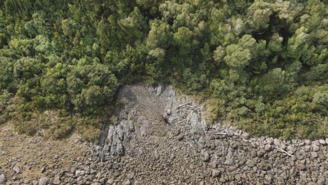
Photo 1
Image created after the photogrammetric process: multiple images taken from a drone.
Photo 2
Front view of the area photographed from above using a drone.
“To undertake an expedition and certain excavations, it is necessary to obtain permits: a process that can take close to two years. When you get to the site, the excavations are made, and then, at the end, everything needs to be covered. Thanks to photogrammetry, the researchers can digitally record the profile and the perfect size of the excavation. It can even be recorded where each object was found”, explains Burbano, a cinema and television producer.
PHOTO 3
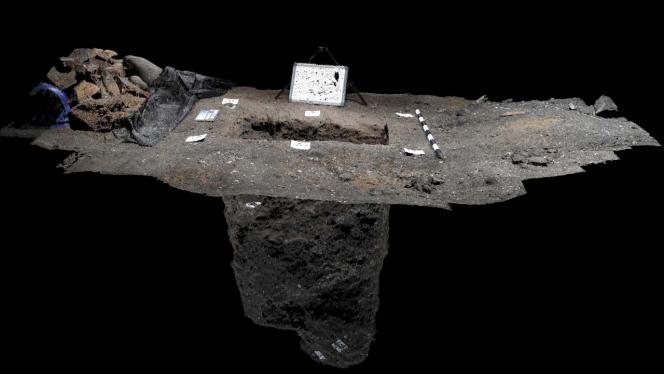 After taking photographs of the excavation site from above, it was possible to create this frontal image.
 The expedition team
A transdisciplinary team with vast experience comprised the project: geologists, archeologists, audiovisualists, and artists from the United States of America, Colombia, New Zealand, and Chile visited the area in April this year.
The following were members of the team:
About professor Burbano
Passionate about fieldwork, Burbano has spent close to ten years accompanying archeological expeditions and documenting the discoveries using digital methods. Ever since 2011 when he became involved in the art of photogrammetry, he has participated in different projects in California, Mexico, and Colombia.
Andrés Burbano has a PhD in media art and technology from the University of California, United States. He completed a Master’s degree in interactive media at the Universidad Ramon Llull in Barcelona and then went to the Center for Art and Media Technology in Karlsruhe, Germany to develop his final year Master’s project.
Share


